| |
The following route was a from a set of three walks
reproduced in a leaflet in 2000, A colour map of these walks
can be found on the wall of the Village Hall,
a black and white copy is available
here
Dogs MUST
be kept on a lead at Stages 1 - 3.
1. Start at the "Jackal" public house, cross the High Street
and walk down the signposted footpath alongside the
Churchyard wall. (St Peter's Church is the
earliest surviving building in the Parish. Over the
centuries it has undergone several re-buildings and
restorations. The oldest part of the church remaining is the
bottom of the central Norman tower with its Adam and Eve
doorway built about 1150AD. In the 15th century the building
took on the shape very much as it is today. In the 1980s a
new roof was installed. Opposite the main door in the
churchyard can be seen the base of a Priest's Cross which
has been declared an ancient monument).
2. Continue down to the brook, keep to the left hand side of
the pond and follow the course of the brook and hedgerow.
Leave the brook and bear left towards the footbridge over
the ditch and the waymarked gate.
3. Through the gate, proceed directly ahead and then turn
right at the waymarked gap in the hedge.
4. Over the footbridge leading across the brook, turn
immediately left and then right following the hedgerow to
Mill Road.
5. Cross the road onto the signposted footpath, down the
slight bank and over the stile. Keep to the right hand side
of the ditched hedgerow and then over the next stile.
(This hedgerow consisting mainly of hawthorn, elder and
brambles produces a mass of 'White May' in Spring and is
rich in wildflowers such as clover, plantain, speedwell,
mayweed and scarlet pimpernel).
6. Continue ahead, turn right at the waymarker on the tree,
over another stile and keep along the well marked footpath
all the way to Old Milton Road. (Horses can be seen
grazing in the paddocks on the left).
7. Cross the road, walk through the small clump of trees on
the raised ground ahead (contains ash, oak, hawthorn and
silver birch), over the main Milton Road and continue
along the signposted hardcore track to Blackburn Hall Farm.
(At the time of Domesday Blackburn Hall and estate
were owned by the de Leye family, it has also been named
Black Bird and Black Bull Hall. The present Hall supports
very ancient chimneys from a much earlier dwelling).
8. Just past the entrance to the Farm cross the track
diagonally, turn right at the waymarker and follow the
hedgerow and ditch around to the next waymarker.
9. Remain on the footpath which turns left and then swings
left and right to the large footbridge. (Ahead can be
seen the vast expanse of the former Thurleigh Airfield.
By 1941 large parts of the Parish had been incorporated into
the airfield first used by Polish airmen flying Wellington
Bombers. In September 1942 it became the base for nearly
2000 airmen and ground crew of the 306th USAAF Bombardment
Group. A memorial to the American serviceman from Thurleigh
who died during the war is in Keysoe Road. Work began
expanding the airfield in 1952 to become part of the Royal
Aircraft Establishment and in 1969 it was short listed as a
site for London's Third Airport. The MOD closed the airfield
in 1996, it now houses Thurleigh Business Park).
10. Turn right over the bridge onto the bridleway and
continue for a short distance to Whitwick Green Road.
11. Turn right again and walk down the road to Church End
and the "Jackal" public house. (Note the many
horsechestnut trees in the parkland on the left and the
picturesque view of the church nestling in the village.
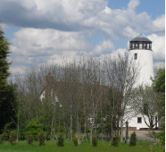
Standing out against the skyline in the distance is the
remains of Thurleigh Windmill. The five floor, sixty feet
tower mill was created in about 1890 and originally
supported four double shutter sails. A base house with a
steam engine was later added to provide steam power. The
mill last worked in 1917).
The
leaflet this walk was taken from was prepared by Thurleigh
Parish Council and Village Members of the Parish Paths
Partnership in conjunction with much appreciated assistance
from the Environmental Service Officers at Bedfordshire
County Council and The British Trust for Conservation
Volunteers (B.T.C.V.). Most of the information about the
village has been taken, with the kind permission of Mrs Judy
Stanton and Mrs Lilian Wildman, from their booklet "Thurleigh
Through The Years" published in 1998.
See all public
footpaths, bridleways and byway open to all traffic (BOAT)
on the
Bedford Borough Council Website |
|